Custom Search
|
|
 
|
||
|
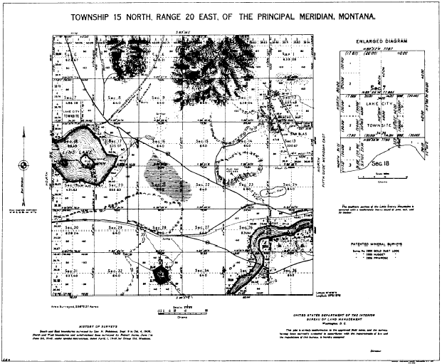
LAND SURVEY GENERAL PROCEDURE As there are no universal rules for the weighing of evidence, so there are no universal, unvarying rules for land-survey procedures. The typical problem, however, usually breaks down into the following major action phases: 1. The location, study, and (when necessary) interpretation of all the available deeds, contracts, maps, wills, or other documents that contain a description of the boundaries. The principal repository for most of these instruments is usually the files in a city or county records office. The mere deciphering of ancient, handwritten documents is an art in itself. And here again it is not unusual to encounter conflicting evidence in the shape of documents that purport to describe the same property but that describe it differently. Or you may find a document in which some of the languages may bear more than one interpretation. In this last case you apply, as well as you can, a legal maxim to the effect that an ambiguous document should be given the sense that the maker of the document may be reasonably presumed to have intended.2. The determination, after study of all the documents and related evidence, of what the true property description may be presumed to be, and from this a determination of what physical evidence of the boundary location exists in the field. Physical evidence means for the most part monuments. In land-surveying speech, a monument is any identifiable object that occupies a permanent location in the field and serves as a reference point or marker for a boundary. A monument may be a natural monument, such as a rock, a tree, or the edge of a stream; or it may be an artificial monument, such as a pipe or a concrete monument. Do not use perishable markers for monuments, such as a wooden marker that decays easily.3. The location, in the field, of the existing physical evidence of the boundaries.4. The establishment of the boundary. That involves those decisions previously mentioned as to the best evidence. It also involves the setting, referencing, and marking of points that should have been marked in previous surveys but were not or that were marked with markers that have since disappeared.5. The preparation of the property description. PLATS OF SURVEYED LANDSThe official plat of a township or other subdivision is the drawing on which is shown the direction and length of each line surveyed, established, retraced, or resurveyed; the relationship to adjoining official surveys; the boundaries, designation, and area of each parcel of land; and, insofar as practical, a delineation of the topography of the area and a representation of the culture and works of man within the survey limits. A subdivision of the public lands is not deemed to have been surveyed or identified until the notes of the field survey have been approved, a plat prepared, the survey accepted by the Director of the Bureau of Land Management as evidenced by a certification to that effect on the plat, and the plat has been filed in the district land office. Figure 10-35 shows a typical township plat. The original drawing shows both a graphical scale and a representative fraction for both the township as a whole and for the enlarged diagram. Because the plat has been photographically reduced, the representative fraction and scale are no longer true. Plats are drawn on sheets of uniform size, 19 inches by 24 inches in trimmed dimensions, for convenience in filing. The usual scale is 1 inch = 40 chains, equivalent to a representative fraction of 1:31,680. Where detail drawings of a portion of the survey area are required, scales of 1 inch = 20 chains or 1 inch = 10 chains may be used. A detail of a small area may be shown (fig. 10-34) as an inset on the main plat. Larger details are drawn on separate sheets. When the drawing is simple, with few topographic or hydrographic
Figure 10-35.Typical township plat. features or works of man to be shown, the entire drawing is in black ink. When, as shown in figure 10-35, the features other than the survey lines are quite extensive, color printing is used. Survey lines, numbers, lettering, and railroads are printed in black; topographic relief, roads, highways, trails, culture, alkali flats, sandy-bottom draws, and sand dunes are shown in brown; rivers, lakes, streams, and marshes are shown by conventional symbols in blue; and timbered areas are indicated in green. Where such a green overprint might obscure other details, the presence of timber may be indicated in a note (fig. 10-35). These several colors are not shown on the reproduction of the plat presented in figure 10-35, although the various features are indicated in appropriate colors on the original map from which this figure was reproduced. A property plat plan must contain the following: 1. Directional orientation, usually indicated by a north arrow.2. Bearing and distance of each boundary. 3. Corner monuments. 4. Names of adjacent owners, inscribed in areas of their property shown.5. Departing property lines. A departing property line is one that runs from a point on one of the boundaries of the surveyed lot through adjacent property. It constitutes a boundary between areas belonging to two adjacent owners,6. Names of any natural monuments that appear on the plat (such as the name of a stream), or the character of any natural monuments (such as "10-inch oak tree") that have no names.7. Title block, showing name of owner, location of property, name of surveyor, date of survey, scale of plat, and any other relevant data.The preceding items are those that usually appear on any plat. Some land surveyors add some or all of the following as well:1. Grid lines or ticks (a grid tick is a marginal segment of a grid line, the remainder of the line between the marginal ticks being omitted), when determinable.2. On a plat on which grid lines or ticks are shown, comer locations by grid plane coordinates.3. Streams, roads, wooded areas, and other natural features, whether or not they serve as natural monuments.4. Surveyors certificate. This is a statement (required by law in many states) in which the surveyor makes a personal affidavit as to the accuracy of the survey, A typical certificate might read as follows: I, (surveyors name), registered land surveyor, hereby certify that this plat accurately shows property of (owners name), as acquired in Deed Book 60, page 75, of the land record of (named) County, State of (name).5. The area of the property. |
 
|
|
|
||