Custom Search
|
|
 
|
||
|
Orientation Symbol Every map you draw has to have an ORIENTATION SYMBOL (sometimes called meridian arrows) on it. The symbol that represents the direction of the meridian is indicated by a needle or feathered arrow pointing north. It must be drawn long enough that it could be transferred accurately to any part of the map. The FULL-HEAD ARROW represents the true meridian; the HALF-HEAD ARROW, the magnetic meridian. If both are drawn, as shown in figure 11-1, the angle between them must be indicated. The general tendency is to draw the symbol in an artistic way; however, the simple design shown in figure 11-1 is adequate for most purposes. If possible, the top of a map must always be oriented north; however, the shape of the mapped area or the most important features of the project may alter this preference.Kinds of Maps Maps are classified according to purpose, scale, or type. Maps classified according to purpose include strategic, tactical, and artillery maps; communications, utilities, or soil maps; and maps pertaining to special studies. When maps are classified according to scale, you have large-scale, medium-scale, and small-scale. Some
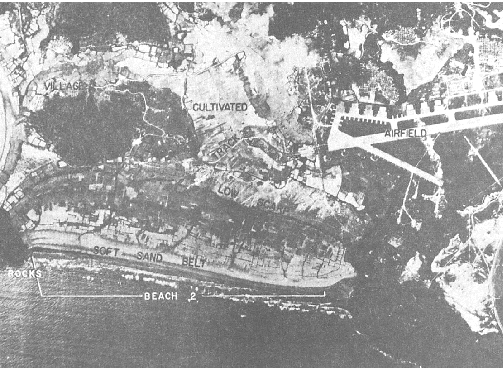
Figure 11-1.-An orientation symbol or meridian arrows. of the more common types, such as geographic, planimetric, topographic, hydrographic, special-purpose, and photomaps or mosaics, are briefly described in the next several paragraphs.GEOGRAPHIC MAPS. A geographic map is a map of a large area, such as that of a state or country, that shows the location of towns, counties, cities, rivers or streams, lakes, roads, and principal civil boundaries, such as county and state lines. Maps showing the general location of the works of people, such as the Railroad Map of the United States, the Irrigation Map of Arizona, and the Panama Canal Zone Map, are classified as geographical maps.PLANIMETRIC MAPS. These maps show natural or man-made features in a horizontal plane only. Relief in a measurable form is omitted. A few examples of planimetric maps are property, maps for city layout, site plan, communications, route and distance, and isogonic maps of the magnetic variation lines.TOPOGRAPHIC MAPS. Maps that depict the natural and man-made features of the earths surface in a measurable form, showing both horizontal and vertical positions are called topographical maps. Vertical positions, or relief, are normally represented by contours. A precise topographic map shows surface features so perfectly that it can be used for making an exact three-dimensional model of the area. Such a model is called a RELIEF MAP. Your work in the SEABEEs will generally concern topographic maps for use in construction.HYDROGRAPHIC MAPS. A hydrographic map shows the shorelines, the location and depth of soundings, and often the topographic and other features of lands adjacent to the shorelines. It also shows the locations of both horizontal and vertical control in the area.SPECIAL-PURPOSE MAPS. These are maps developed for specific purposes. A PRELIMINARY MAP developed from a preliminary survey of a highway, a LOCATION MAP showing the alignment of the located line, and a RIGHT-OF-WAY MAP showing the boundaries of the right-of-way and the adjacent lands all come under the heading of special-purpose maps.MOSAIC AND OVERLAYS. The aerial photographic mosaic is constructed from two or more overlapping prints joined so that they form a single picture. Usually, vertical photographs are used and a maplike result is obtained; however, oblique photographs may be used, in which case the result is a panorama. The mosaic has become increasingly useful in cartography and related fields since World War I. Large geographic areas may be represented in this manner with each feature of terrain assuming its natural appearance and approximating its proportionate size. The U.S. Army Topographic Command has a vari-colored map of the entire United States and other countries that was developed from mosaics. The Army calls it a PICTOMAP; this is the type of map that is generally used in a war zone. Aerial photographs may be converted into line maps by the use of overlays. Usually, these are made by tracing the details from the photograph on transparent paper or vellum and adding such marginal data as desired. This line map may then be reproduced quickly by blueprinting or by lithography. Figure 11-2 shows a vertical aerial
Figure 11-2.-Example of an aerial photograph. photograph, and figure 11-3 shows the line map made by the use of overlays. |
 
|
|
|
||